


South Australia’s pioneering satellite, Kanyini, has made history once again, delivering its first images from space.
Deployed on SpaceX’s Transporter-11 mission in August 2024, Kanyini has been closely monitored since launching by the mission control team based at Inovor Technologies at Lot Fourteen.
The team has been working through commissioning of the satellite’s systems, confirming that the solar panels and batteries are functional and X-band radio communications are all operational.
A number of preliminary images have been collected during Kanyini’s on-orbit commissioning phase, demonstrating the incredible depth of data the satellite will be able to provide once fully operational.
The first processed images released publically, capture high resolution views of South Australian regions including Kangaroo Island, Yorke Peninsula and Adelaide. The milestone marks an exciting moment for the mission team on its path to becoming fully operational and ensuring the satellite can deliver critical real-world benefits.
SmartSat CRC Chief Executive Officer, Professor Andy Koronios said work was ongoing to ensure the success of the mission.
“These first images are the result of years of hard work and dedication from our talented team of engineers as they work through the onboard commissioning of the spacecraft,” Mr Koronios said.
“SmartSat is proud to be funding a suite of projects in artificial intelligence, onboard processing and machine learning aimed at using the data gathered by Kanyini to address challenges in agriculture, water management and the environment.”
The HyperScout 2 hyperspectral imager capturing the images is a three-in-one instrument that combines hyperspectral and thermal imaging with high-level data processing and Artificial Intelligence capabilities.
The vast amount of data behind each image allows them to be processed to reveal infrared details ordinarily invisible to the human eye, that can be used in monitoring crop health, vegetation density and changes in inland and coastal water conditions.
The satellite also features an Internet of Things (IoT) payload developed and manufactured in South Australia by Myriota, enabling Kanyini to capture both imagery and IoT data – such as groundwater levels and pipeline condition – from a single satellite.
Myriota Chief Technology Officer & Co-Founder, Dr David Haley said every step of the commissioning process was helping to realise Kanyini’s mission to harness the power of space to benefit people on earth.
“We have tested and proven Myriota’s home-grown IoT payload and are now integrating Kanyini into Myriota’s satellite network where it will soon join our global connectivity service,” Mr Haley said.
“We are incredibly excited to be able to utilise a collaborative, South Australian-made satellite to communicate data that improves the management of key resources, both here in South Australia and beyond.”
Inovor Technologies Chief Executive Officer Dr Matt Tetlow said the delivery of the first images was a proud moment for the mission team.
“This achievement reinforces Australia’s growing sovereign capability in space technology. We look forward to further calibration and data collection in the coming months,” he said.
Once fully operational, Kanyini will deliver critical space data to support future research projects by government and research institutions, particularly in the areas of sustainability and climate impacts.
Australia’s first state-owned satellite, the Kanyini mission is a joint initiative between the South Australian Government, SmartSat CRC, Inovor Technologies and Myriota.
Kanyini fast facts
- Revolutions around the Earth: 2788
- Average speed: 27,386 km/hr
- Distance travelled: 9,034,937 km
- Orbit height: 516km

Adelaide
This real colour image that captures the Adelaide CBD was taken by Kanyini on 3 February 2025. The colour shows the Earth below as it would appear to the human eye if viewed from Low Earth Orbit. Colour images such as this can be used to observe and monitor changes in the landscape, as well as assist in land management and agricultural planning.
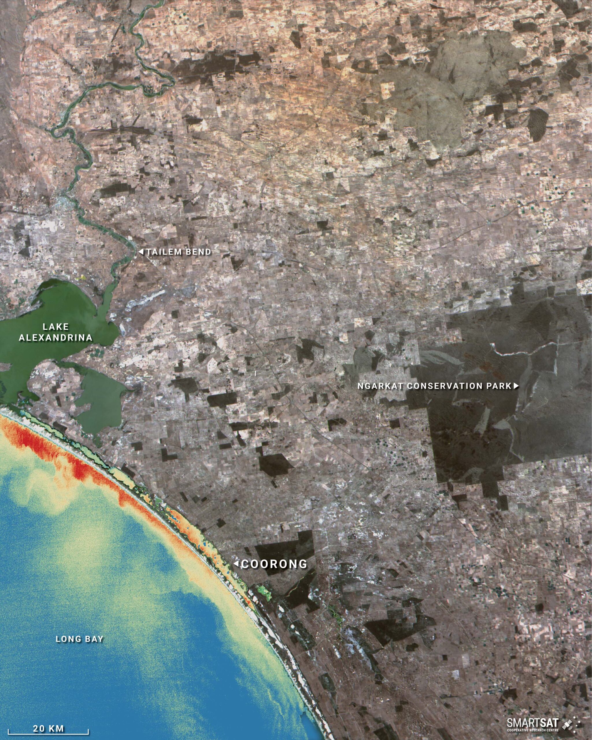
Coorong (Turbidity Index)
This hyperspectral image of the Coorong feeding into Long Bay, taken on 19 December 2024, has been processed to show the Turbidity Index of the coastal waters. Turbidity Indices highlight the level of sediment particles within bodies of water, allowing users to analyse the turbulence of movement in bodies of water and changes in sediment flows. Particles floating in the water reflect light, which can be shown more clearly using the satellite data to create an image such as this.
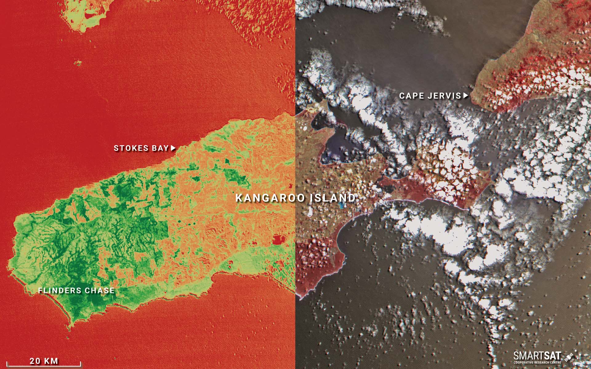
Kangaroo Island
Hyperspectral image of Kangaroo Island, taken on 2 January 2025. On the left is a Normalised Vegetation Difference Index (NDVI), allowing users to analyse the health, or 'greenness', of vegetation by showing how it interacts with red and near-infrared light. NDVI is a quick and easy way to get a "greenness score" from satellite images, helping us understand vegetation health, density, and changes over time. Healthy, dense vegetation is displayed as bright green, with less healthy or lower levels of vegetation appearing in light green or yellow. Dead vegetation or areas of low or no vegetation appear in red. On the right is Colour Infrared Imagery, representing light beyond what the human eye can see, specifically infrared. Areas with lush, green vegetation, reflecting more infrared light, are displayed in vibrant red. Vegetation that is less green, less dense, or under stress, reflecting less infrared, will appear as paler reds or pinks. This allows users to visually assess variations in vegetation conditions.